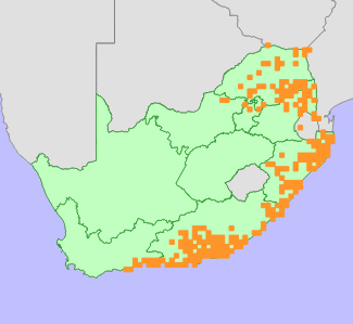
| Scientific Name | Panicum deustum Thunb. | Higher Classification | Monocotyledons | Family | POACEAE | Common Names | Breeblaarwintergras (a), Breëblaarwintergras (a), Bufalo Grass (e), Buffelsgras (a), Reed Panicum (e), Rietbuffelgras (a), Rietbuffelsgras (a) |
National Status | Status and Criteria | Least Concern | Assessment Date | 2020/02/28 | Assessor(s) | L. von Staden | Justification | Panicum deustum is widespread, common and not in danger of extinction. It is therefore assessed as Least Concern. |
Distribution | Endemism | Not endemic to South Africa | Provincial distribution | Eastern Cape, Gauteng, KwaZulu-Natal, Limpopo, Mpumalanga, North West, Western Cape | Range | This species is widespread across the hotter, low-lying areas of eastern South Africa, from the Limpopo River Valley through the Mpumalanga Lowveld to the KwaZulu-Natal coast, southwards to the southern Cape coast near Riversdale. It is widespread across tropical Africa as far north as Ethiopia. |
Habitat and Ecology | Major system | Terrestrial | Major habitats | Subtropical Alluvial Vegetation, Fish Arid Thicket, Fish Valley Thicket, Waterberg Mountain Bushveld, Sekhukhune Montane Grassland, Pondoland-Ugu Sandstone Coastal Sourveld, South Eastern Coastal Thornveld, Maputaland Coastal Belt, Zululand Lowveld, Albany Alluvial Vegetation, Sundays Arid Thicket, Sundays Mesic Thicket, Sundays Valley Thicket, Sekhukhune Mountain Bushveld, Sekhukhune Plains Bushveld, KwaZulu-Natal Coastal Belt Grassland, Bhisho Thornveld, Granite Lowveld, Southern Afrotemperate Forest, Albany Valley Thicket, Eastern Valley Bushveld, Phalaborwa-Timbavati Mopaneveld, Scarp Forest, Garden Route Shale Fynbos, Northern Coastal Forest, South Outeniqua Sandstone Fynbos, Midlands Mistbelt Grassland, Hamburg Dune Thicket, Dry Coast Hinterland Grassland, Kouga Grassy Sandstone Fynbos, Central Sandy Bushveld, Moist Coast Hinterland Grassland, Lowveld Riverine Forest, Knysna Sand Fynbos, Maputaland Wooded Grassland, Northern Afrotemperate Forest, Transkei Coastal Belt, KwaZulu-Natal Coastal Belt Thornveld, Southern Mistbelt Forest, Northern Mistbelt Forest, Soutpansberg Mountain Bushveld, Amathole Montane Grassland, Sand Forest, Swamp Forest, Hartenbos Dune Thicket, Gabbro Grassy Bushveld, Doubledrift Karroid Thicket, Tsitsikamma Sandstone Fynbos, Western Maputaland Clay Bushveld, Goukamma Dune Thicket, Grahamstown Grassland Thicket, Tembe Sandy Bushveld, Escarpment Mesic Thicket, Southern Lebombo Bushveld, Northern Zululand Sourveld, Makhado Sweet Bushveld, Kasouga Dune Thicket, Motherwell Karroid Thicket, Nanaga Savanna Thicket, Ohrigstad Mountain Bushveld, Albany Mesic Thicket, Grass Ridge Bontveld, Albany Bontveld, Elands Forest Thicket, Eastern Gwarrieveld, Crossroads Grassland Thicket, Suurberg Quartzite Fynbos, Buffels Mesic Thicket, Canca Limestone Fynbos, Baviaans Valley Thicket, Buffels Valley Thicket, Escarpment Arid Thicket, Suurberg Shale Fynbos, Garden Route Granite Fynbos, Escarpment Valley Thicket, Fish Mesic Thicket, Thorndale Forest Thicket, Eastern Coastal Shale Band Vegetation, Subtropical Dune Thicket, Saltaire Karroid Thicket, St Francis Dune Thicket, Groot Brak Dune Strandveld, Vanstadens Forest Thicket, Umtiza Forest Thicket, Swellendam Silcrete Fynbos, Tshokwane-Hlane Basalt Lowveld, Malelane Mountain Bushveld, Kaalrug Mountain Bushveld, Swaziland Sour Bushveld, Northern Lebombo Bushveld, Lebombo Summit Sourveld, Western Maputaland Sandy Bushveld, Nwambyia-Pumbe Sandy Bushveld, Makatini Clay Thicket, Zululand Coastal Thornveld, Maputaland Pallid Sandy Bushveld, Ironwood Dry Forest, Crocodile Gorge Mountain Bushveld, Marikana Thornveld, Tzaneen Sour Bushveld, Legogote Sour Bushveld, Musina Mopane Bushveld, Limpopo Ridge Bushveld, Cathedral Mopane Bushveld, Tsende Mopaneveld, Thukela Valley Bushveld, Thukela Thornveld, KwaZulu-Natal Hinterland Thornveld, KwaZulu-Natal Sandstone Sourveld, Muzi Palm Veld and Wooded Grassland, Steenkampsberg Montane Grassland, Algoa Sandstone Fynbos, Loerie Conglomerate Fynbos, Southern Coastal Forest, Albany Arid Thicket, Humansdorp Shale Renosterveld, Karoo Escarpment Grassland, Rand Highveld Grassland, Barberton Montane Grassland, Lydenburg Thornveld, Northern Escarpment Quartzite Sourveld, Pretoriuskop Sour Bushveld, Soutpansberg Summit Sourveld, Makuleke Sandy Bushveld, Long Tom Pass Montane Grassland, East Griqualand Grassland, Tarkastad Montane Shrubland, Bedford Dry Grassland, KwaZulu-Natal Highland Thornveld, Dwaalboom Thornveld, Loskop Mountain Bushveld, Springbokvlakte Thornveld, Poung Dolomite Mountain Bushveld, Pilanesberg Mountain Bushveld, Kouga Sandstone Fynbos, Wolkberg Dolomite Grassland | Description | It occurs in moist clay, loam or sandy soils in shady places on rocky hillsides or in margins of forest or bush clumps. |
Population | Population trend | Stable |
Assessment History |
Taxon assessed |
Status and Criteria |
Citation/Red List version | | Panicum deustum Thunb. | Least Concern | Raimondo et al. (2009) | |
Bibliography | Clayton, W.D. 1989. Gramineae. In: E. Launert and G.V. Pope (eds). Flora Zambesiaca 10 (Part 3):1-220. Flora Zambesiaca Managing Committee, London.
Fish, L., Mashau, A.C., Moeaha, M.J. and Nembudani, M.T. 2015. Identification guide to southern African grasses. Strelitzia 36. South African National Biodiversity Institute, Pretoria.
Goldblatt, P. and Manning, J.C. 2000. Cape Plants: A conspectus of the Cape Flora of South Africa. Strelitzia 9. National Botanical Institute, Cape Town.
Raimondo, D., von Staden, L., Foden, W., Victor, J.E., Helme, N.A., Turner, R.C., Kamundi, D.A. and Manyama, P.A. 2009. Red List of South African Plants. Strelitzia 25. South African National Biodiversity Institute, Pretoria.
|
Citation | | von Staden, L. 2020. Panicum deustum Thunb. National Assessment: Red List of South African Plants version 2024.1. Accessed on 2026/02/05 |
 Comment on this assessment Comment on this assessment
|
Search for images of Panicum deustum on iNaturalist
|
 Comment on this assessment

