|
Scientific Name | Hermannia sandersonii Harv. |
Higher Classification | Dicotyledons |
Family | MALVACEAE |
Common Names | Umakotegoyile (z) |
National Status |
Status and Criteria | Vulnerable B1ab(iii,v) |
Assessment Date | 2006/11/15 |
Assessor(s) | D. Raimondo |
Justification | EOO 640 km², less than 10 known locations of this palatable species continue to decline due to livestock overgrazing. More than 30% of its habitat has been lost to commercial forestry plantations and crop cultivation, but generation length is unknown. |
Distribution |
Endemism | South African endemic |
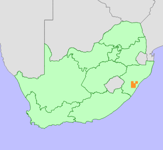
Provincial distribution | KwaZulu-Natal |
Range | Camperdown, New Hanover, Pietermaritzburg, Durban, Umgeni and Glenside on the Noodsberg. |
Habitat and Ecology |
Major system | Terrestrial |
Major habitats | Eastern Valley Bushveld, KwaZulu-Natal Sandstone Sourveld, KwaZulu-Natal Hinterland Thornveld, Dry Coast Hinterland Grassland |
Description | Natal Group Sandstone, on steep slopes in silty sand. |
Threats |
| Invasive Alien Species (direct effects), Habitat degradation, Harvesting [gathering], Habitat loss |
Population |
Population trend | Decreasing |
Assessment History |
Taxon assessed |
Status and Criteria |
Citation/Red List version | | Hermannia sandersonii Harv. | VU B1ab(iii,v) | Raimondo et al. (2009) | | Hermannia sandersonii Harv. | Indeterminate | Hilton-Taylor (1996) | |
Bibliography |
Hilton-Taylor, C. 1996. Red data list of southern African plants. Strelitzia 4. South African National Botanical Institute, Pretoria.
Raimondo, D., von Staden, L., Foden, W., Victor, J.E., Helme, N.A., Turner, R.C., Kamundi, D.A. and Manyama, P.A. 2009. Red List of South African Plants. Strelitzia 25. South African National Biodiversity Institute, Pretoria.
|
Citation |
| Raimondo, D. 2006. Hermannia sandersonii Harv. National Assessment: Red List of South African Plants version 2024.1. Accessed on 2025/12/05 |
 Comment on this assessment

