| Scientific Name | Aloe micracantha Haw. | Higher Classification | Monocotyledons | Family | ASPHODELACEAE | Common Names | Wateraalwee (a), Wateraalwyn (a) |
National Status | Status and Criteria | Near Threatened B1ab(ii,iii,iv,v) | Assessment Date | 2018/11/12 | Assessor(s) | H. Mtshali & L. von Staden | Justification | This species has a restricted distribution range (EOO 9500-11 804 km²), and is declining due to ongoing habitat loss and degradation over most of its range. Recent field observations however confirm that it is still fairly common, remaining at between 17 and 24 locations, and therefore it nearly meets the thresholds for Vulnerable under criterion B. |
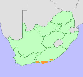
Distribution | Endemism | South African endemic | Provincial distribution | Eastern Cape, Western Cape | Range | This species is endemic to the Western and Eastern Cape provinces of South Africa, where it occurs from near Uniondale eastwards along the coastal mountains to Port Elizabeth, and inland to the Kap River Mountains north-east of Grahamstown. |
Habitat and Ecology | Major system | Terrestrial | Major habitats | Kouga Grassy Sandstone Fynbos, Loerie Conglomerate Fynbos, Algoa Sandstone Fynbos, Kouga Sandstone Fynbos, Tsitsikamma Sandstone Fynbos, South Outeniqua Sandstone Fynbos, Suurberg Quartzite Fynbos | Description | It occurs on lower slopes and flats in grassy fynbos, 0-700 m. |
Threats | | Subpopulations around Port Elizabeth are severely threatened by ongoing habitat loss to urban expansion and infrastructure development. Around Humansdorp, it has lost habitat to agriculture in the past, and is currently threatened by habitat loss to renewable energy developments as well as overgrazing. On the northern slopes of the Outeniqua Mountains between Knysna and Uniondale it has lost habitat to commercial timber plantations in the past, and remaining subpopulations are mainly threatened by escaped pine seedlings and other invasive species spreading uncontrolled into remaining wild fynbos, where they outcompete native species. In the Lang Kloof between Uniondale and Kareedouw, subpopulations occurring along the valley bottom have been lost to agricultural expansion in the past. Habitat remains on lower sandstone slopes, but need to be surveyed to confirm how many subpopulations remain. To the east of Grahamstown, habitat has been lost and degraded due to agricultural expansion, alien invasive species and overgrazing. To the south of Grahamstown, one known remaining subpopulation is potentially threatened by inappropriate fire management. |
Population | It is known historically from a large number of records scattered over a wide area. Recent field observations indicate that it still persists at many locations in the Humansdorp and Port Elizabeth areas, although subpopulations in these areas are becoming increasingly fragmented due to habitat loss to urban and other developments. Six known locations in the Port Elizabeth area are under imminent threat of loss to urban development.
Field surveys indicate that subpopulations are small, even within montane areas with large amounts of remaining suitable habitat, and the largest known subpopulation consists of about 140 mature individuals. With field counts of number of mature individuals available for 11 out of 17 recently recorded locations, and if it is assumed that known records represent the only remaining subpopulations, this species possibly has a population size of less than 1000 mature individuals. However, large areas of remaining suitable habitat in the Kouga, Outeniqua and Tsitsikamma Mountains along the Lang Kloof remain poorly explored, and therefore this is likely to be an underestimate. It was last recorded between Uniondale and Kareedouw in 1953. While it is likely to have declined due to historical habitat loss to agriculture in the Lang Kloof, the lack of recent records from this area is most likely due to a lack of field surveys, rather than local extinction.
The species was last recorded to the east of Grahamstown in 1936. Most of this area is now degraded due to agriculture, alien invasive species and overgrazing, and field surveys are needed to confirm whether the species is still present.
| Population trend | Decreasing |
Assessment History |
Taxon assessed |
Status and Criteria |
Citation/Red List version | | Aloe micracantha Haw. | NT B1ab(ii,iii,iv,v) | Raimondo et al. (2009) | | Aloe micracantha Haw. | VU A1aceB1B2ac | Victor (2002) | | Aloe micracantha Haw. | Rare | Hilton-Taylor (1996) | |
Bibliography | Goldblatt, P. and Manning, J.C. 2000. Cape Plants: A conspectus of the Cape Flora of South Africa. Strelitzia 9. National Botanical Institute, Cape Town.
Hilton-Taylor, C. 1996. Red data list of southern African plants. Strelitzia 4. South African National Botanical Institute, Pretoria.
Raimondo, D., von Staden, L., Foden, W., Victor, J.E., Helme, N.A., Turner, R.C., Kamundi, D.A. and Manyama, P.A. 2009. Red List of South African Plants. Strelitzia 25. South African National Biodiversity Institute, Pretoria.
Smith, G.F. 1993. Notes on the taxonomic and conservation status of Aloe micracantha (Asphodelaceae: Alooideae). Haseltonia 1:55-60.
Smith, G.F., Steyn, E.M.A., Victor, J.E., Crouch, N.R., Golding, J.S. and Hilton-Taylor, C. 2000. Aloaceae: The conservation status of Aloe in South Africa: an updated synopsis. Bothalia 30(2):206-211.
Van Wyk, B.-E. and Smith, G. 1996. Guide to the aloes of South Africa. Briza Publications, Pretoria.
Van Wyk, B.-E. and Smith, G. 2003. Guide to aloes of South Africa. (2nd ed.). Briza Publications, Pretoria.
Victor, J.E. 2002. South Africa. In: J.S. Golding (ed), Southern African plant Red Data Lists. Southern African Botanical Diversity Network Report 14 (pp. 93-120), SABONET, Pretoria.
|
Citation | | Mtshali, H. & von Staden, L. 2018. Aloe micracantha Haw. National Assessment: Red List of South African Plants version 2024.1. Accessed on 2025/12/23 |
 Comment on this assessment Comment on this assessment
|
Search for images of Aloe micracantha on iNaturalist
|
 Comment on this assessment

