|
Scientific Name | Crassula simulans Schönland |
Higher Classification | Dicotyledons |
Family | CRASSULACEAE |
National Status |
Status and Criteria | Vulnerable D2 |
Assessment Date | 2007/04/28 |
Assessor(s) | D. Raimondo & N.A. Helme |
Justification | Known from less than five locations and potentially threatened by invasive alien plants, crop cultivation and urban expansion. |
Distribution |
Endemism | South African endemic |
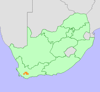
Provincial distribution | Western Cape |
Range | Worcester to Robertson and Montagu. |
Habitat and Ecology |
Major system | Terrestrial |
Major habitats | Western Little Karoo, Robertson Karoo, Breede Shale Renosterveld, Montagu Shale Renosterveld, Matjiesfontein Shale Renosterveld, Breede Alluvium Renosterveld |
Description | Shaded, moist, south-facing slopes. |
Threats |
| Potentially threatened by habitat loss to urban expansion and crop cultivation and competition from alien invasive plants. |
Population |
Population trend | Stable |
Assessment History |
Taxon assessed |
Status and Criteria |
Citation/Red List version | | Crassula simulans Schönland | VU D2 | Raimondo et al. (2009) | |
Bibliography |
Goldblatt, P. and Manning, J.C. 2000. Cape Plants: A conspectus of the Cape Flora of South Africa. Strelitzia 9. National Botanical Institute, Cape Town.
Raimondo, D., von Staden, L., Foden, W., Victor, J.E., Helme, N.A., Turner, R.C., Kamundi, D.A. and Manyama, P.A. 2009. Red List of South African Plants. Strelitzia 25. South African National Biodiversity Institute, Pretoria.
Tölken, H.R. 1985. Crassulaceae. In: O.A. Leistner (ed). Flora of southern Africa 14,1:1-244. Botanical Research Institute, Pretoria.
|
Citation |
| Raimondo, D. & Helme, N.A. 2007. Crassula simulans Schönland. National Assessment: Red List of South African Plants version 2024.1. Accessed on 2026/02/18 |
 Comment on this assessment


