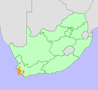
|
Scientific Name | Lampranthus stenopetalus (L.Bolus) N.E.Br. |
Higher Classification | Dicotyledons |
Family | AIZOACEAE |
Synonyms | Mesembryanthemum stenopetalum L.Bolus |
National Status |
Status and Criteria | Vulnerable B1ab(i,ii,iii,iv,v) |
Assessment Date | 2006/06/08 |
Assessor(s) | C. Klak & D. Raimondo |
Justification | EOO 11 500 km², seven locations remain after >50% of known subpopulations are now locally extinct due to urban expansion on the Cape Flats. It continues to decline due to habitat loss to alien plant invasion, further urban development, and potato and wheat cultivation, especially around Graafwater. |
Distribution |
Endemism | South African endemic |
Provincial distribution | Western Cape |
Range | Graafwater to Cape Flats and Villiersdorp. |
Habitat and Ecology |
Major system | Terrestrial |
Major habitats | South Sonderend Sandstone Fynbos, North Sonderend Sandstone Fynbos, Breede Sand Fynbos, Cape Flats Sand Fynbos, Atlantis Sand Fynbos, Hopefield Sand Fynbos, Leipoldtville Sand Fynbos, Breede Alluvium Fynbos |
Description | Lowland sand fynbos. |
Threats |
| Invasive Alien Species (direct effects), Habitat loss |
Population |
Population trend | Decreasing |
Assessment History |
Taxon assessed |
Status and Criteria |
Citation/Red List version | | Lampranthus stenopetalus (L.Bolus) N.E.Br. | VU B1ab(i,ii,iii,iv,v) | Raimondo et al. (2009) | |
Bibliography |
Raimondo, D., von Staden, L., Foden, W., Victor, J.E., Helme, N.A., Turner, R.C., Kamundi, D.A. and Manyama, P.A. 2009. Red List of South African Plants. Strelitzia 25. South African National Biodiversity Institute, Pretoria.
|
Citation |
| Klak, C. & Raimondo, D. 2006. Lampranthus stenopetalus (L.Bolus) N.E.Br. National Assessment: Red List of South African Plants version 2024.1. Accessed on 2026/01/26 |
 Comment on this assessment


